| Title | TN Sullivan Massengill | ||||||||||||||||||||||||||||||||||||||||||||||||||
| Site Image | 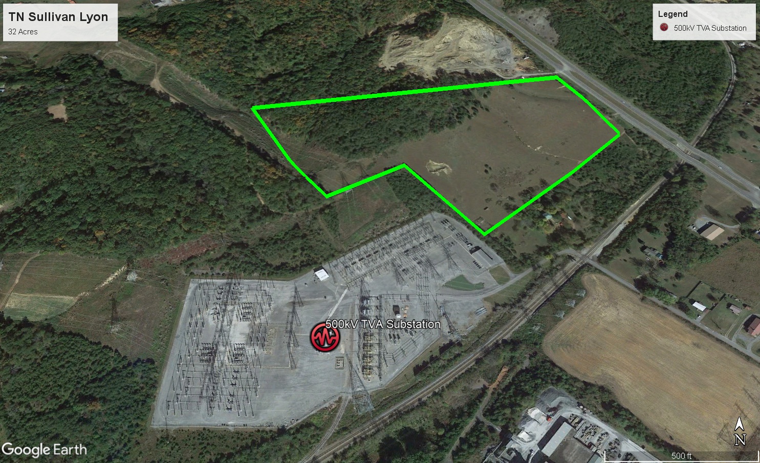 | ||||||||||||||||||||||||||||||||||||||||||||||||||
| Site Use Types | |||||||||||||||||||||||||||||||||||||||||||||||||||
Open Doors Contact | Lane Sharman +1-858-342-1415 lane.sharman@opendoors.com | ||||||||||||||||||||||||||||||||||||||||||||||||||
| Developer Contact | |||||||||||||||||||||||||||||||||||||||||||||||||||
| Site Status | Under Contract | ||||||||||||||||||||||||||||||||||||||||||||||||||
| Total Site Acreage | 31.2 | Estimated Buildable Acreage | |||||||||||||||||||||||||||||||||||||||||||||||||
| County | Sullivan | ||||||||||||||||||||||||||||||||||||||||||||||||||
| State | TN | ||||||||||||||||||||||||||||||||||||||||||||||||||
| Energy Community | No | Justice Forty Tract | Yes | ||||||||||||||||||||||||||||||||||||||||||||||||
| FIPS Census Tract Code | 47163043302 | Fiber Proximity | |||||||||||||||||||||||||||||||||||||||||||||||||
| Tax Credit | |||||||||||||||||||||||||||||||||||||||||||||||||||
| Summary | Excellent site for a large BESS connected to 500KV TVA Substation. | ||||||||||||||||||||||||||||||||||||||||||||||||||
| Latitude | 36.445015 | The L/L fields are the Point of Interconnection for the Site | |||||||||||||||||||||||||||||||||||||||||||||||||
| Longitude | -82.276725 | Low Income Tract | |||||||||||||||||||||||||||||||||||||||||||||||||
| Google Map | 36.445015,-82.276725 | ||||||||||||||||||||||||||||||||||||||||||||||||||
| Public KMZ File | |||||||||||||||||||||||||||||||||||||||||||||||||||
| Alternate Contact | Emil Botes | ||||||||||||||||||||||||||||||||||||||||||||||||||
| KMZ File | Custom_Parcel_Search_29e46c02.kmz | ||||||||||||||||||||||||||||||||||||||||||||||||||
| Site Analytics | |||||||||||||||||||||||||||||||||||||||||||||||||||
| Local Utility | Bristol Tennessee Essential Services | ||||||||||||||||||||||||||||||||||||||||||||||||||
| Interconnection Brief | Interconnection is with the Tennessee Valley Authority, a Federal Agency. Substation: Sullivan 3 x 500KV Lines Substations interconnected to Sullivan: Nagel, Phillips Bend, Broadford (765KV) 7 x 161KV Lines Substations interconnected to Sullivan: Taps, Bluff City, Blountville SW Station, Boone Dam, North Johnson, Elizabethton The Broadford (765KV) is owned by Appalachian Power, a member of PJM. | ||||||||||||||||||||||||||||||||||||||||||||||||||
| Owner & Site Brief | Owner is seeking a long term lease agreement. | ||||||||||||||||||||||||||||||||||||||||||||||||||
| Development Brief | Owner will develop a 2 acre lot on the frontage road, the eastern boundary. Open Doors seeks to transfer site control under a Site Control Assignment to an energy storage developer. To develop on this site, please email emil.botes@opendoors.com or lane.sharman@opendoors.com | ||||||||||||||||||||||||||||||||||||||||||||||||||
| Moratoriums of Any Type | ISO | ||||||||||||||||||||||||||||||||||||||||||||||||||
| Site Sequence Number | 218 | ||||||||||||||||||||||||||||||||||||||||||||||||||
| Industrial Rate Per KwH | |||||||||||||||||||||||||||||||||||||||||||||||||||
Site Characteristics | |||||||||||||||||||||||||||||||||||||||||||||||||||
| Characteristic Sequence Number | Type | Notes | URL | Map URL | Image | File | |||||||||||||||||||||||||||||||||||||||||||||
| 00621 | Queue Analysis | Consult this queue prior to any final land acquisition decision. | http://www.oasis.oati.com/woa/docs/TVA/TVAdocs/OASIS_CurrentQueue.pdf | https://opendoors.maps.arcgis.com/home/webmap/viewer.html?webmap=1a8b8f871e4546bbbb51d488f8d7bf92&find=, | |||||||||||||||||||||||||||||||||||||||||||||||
| 681 | Sullivan Co. TN Zoning |
| https://opendoors.maps.arcgis.com/home/webmap/viewer.html?webmap=1a8b8f871e4546bbbb51d488f8d7bf92&find=, | ||||||||||||||||||||||||||||||||||||||||||||||||
URLs, Images and Artifacts | |||||||||||||||||||||||||||||||||||||||||||||||||||
| URL Label | URL Value | Record ID | File | Image Set | |||||||||||||||||||||||||||||||||||||||||||||||
| Current TVA Solar Projects | https://www.tva.com/environment/environmental-stewardship/environmental-reviews#solar | 226 | |||||||||||||||||||||||||||||||||||||||||||||||||
| TVA Solar Panel Approvals Article | https://www.tva.com/environment/shoreline-construction-permits/solar-panel-approvals | 230 | |||||||||||||||||||||||||||||||||||||||||||||||||
| Tennessee Valley Authority Contacts | http://www.oasis.oati.com/woa/docs/TVA/TVAdocs/Contact_List_20221118.pdf | 00157 | |||||||||||||||||||||||||||||||||||||||||||||||||